Exploration and Drilling
Modern rig technology, the evolution of horizontal drilling, and the geophysics that finds gas before the bit hits the rock.
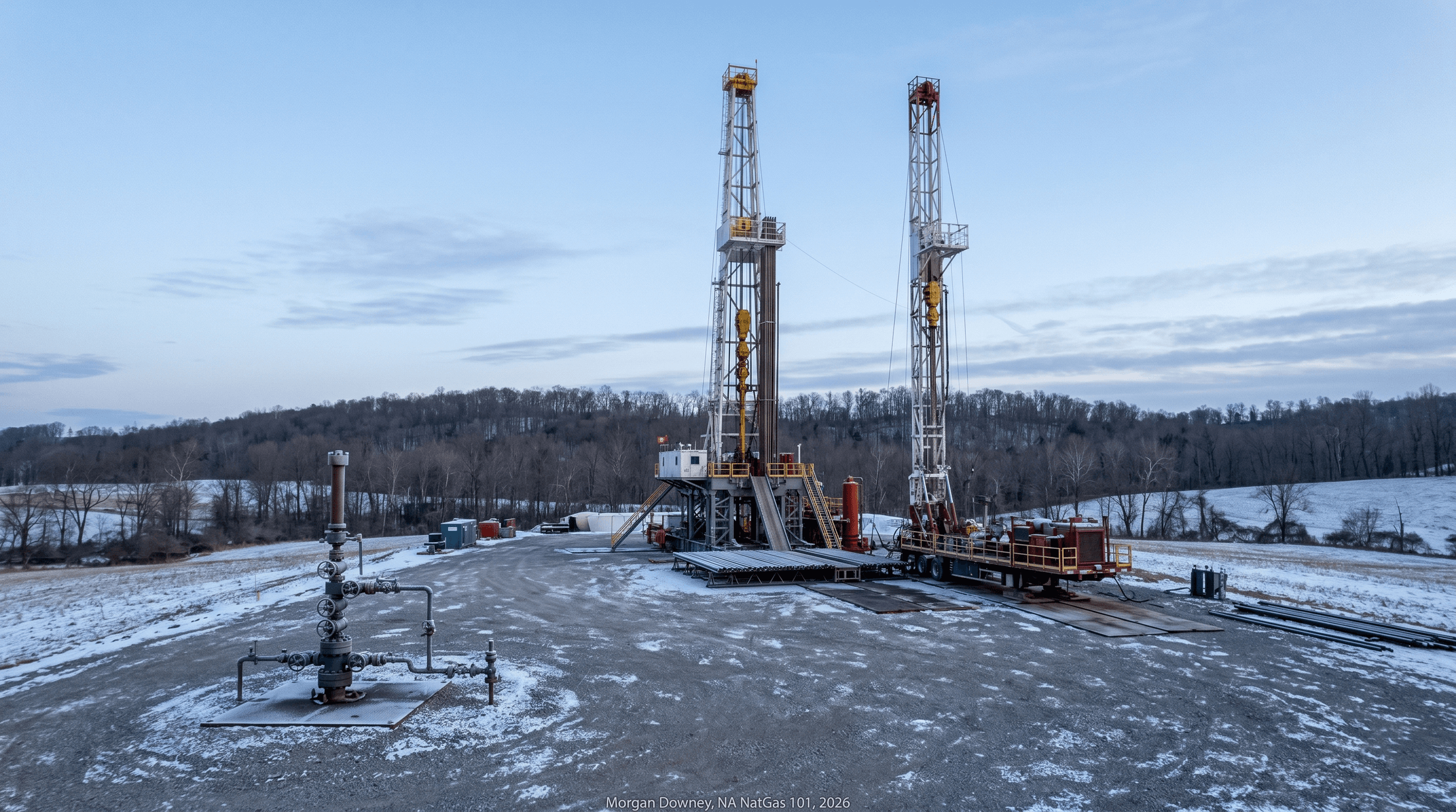
Two hours before dawn on a January morning in 2024, a Helmerich & Payne FlexRig 5 sat over the eighth surface location of a 12-well row on a 7-acre pad at the edge of a Wyoming County, Pennsylvania, dairy farm. Well number 8 had reached total depth of 19,400 feet measured from the rig floor 14 hours earlier, with about 11,500 feet of horizontal lateral landed in the Middle Devonian Marcellus shale at a true vertical depth of 7,400 feet. The production casing was cemented, the wireline crew had finished its cement bond log, and the rig crew had a single overnight shift to walk the rig 25 feet to the south so it could spud well number 9 before the day shift drove up the access road.
The walk took four hours. Hydraulic cylinders housed in the rig substructure released the anchor pins. Eight steel skid shoes lifted the entire 200-foot rig assembly above 1.5 million pounds of weight just enough to clear the pad surface. Forward and lateral cylinders extended in slow synchronized strokes, advancing the rig in 6-inch increments across heavy steel mat plates set into the pad’s compacted gravel base. By 5:30 AM the rig was repositioned over the next surface location, the BOP stack was being lowered into place, and the day driller was running through the morning safety briefing. By noon the bit was turning into the conductor casing that had been pre-drilled to 80 feet during pad construction the previous summer.
The 12-well pad will produce more than 130 million cubic feet per day at peak from a surface footprint of 7 acres. Drilled by 50 vertical wells in the conventional era, the same gas would have required thousands of acres of surface disturbance, several dozen pad locations, and a service-road network the local township would have spent a decade litigating. The walking rig, the multi-well pad, and the horizontal lateral are the three operational technologies that turned a low-permeability source rock into the largest gas-producing region in the United States.
Finding Gas: Seismic and the Prospect
Conventional exploration starts with a prospect map. A geologist looks at well logs from offset wells, regional gravity and magnetic data, and seismic data acquired by a contractor or licensed from a vendor. The prospect is a specific structural or stratigraphic feature mapped from the seismic interpretation that the geologist believes can host trapped gas. Each prospect costs millions of dollars to test with a single vertical well. A failed test means the seismic was misread, the trap was breached, the migration pathway never delivered gas, or the source rock was less mature than predicted.
Seismic acquisition uses controlled energy sources to send acoustic energy into the subsurface and measures the reflections. On land the source is a vibroseis truck, a heavy-duty rig that hammers a steel pad against the ground at sweeping frequencies between roughly 10 and 100 Hz. Offshore the source is a towed airgun array. Geophones on land and hydrophones at sea pick up the reflected energy and feed it into a recording truck or boat. 2D seismic acquires data along single straight lines and produces vertical cross-sections through the subsurface. 3D seismic acquires a dense grid that produces a true volumetric image of the subsurface, with interpretation done at any horizontal slice or vertical cross-section through the data cube. 4D, also called time-lapse 3D, acquires the same survey area at intervals of months to years to monitor changes in producing reservoirs as fluid is withdrawn or injected. 4D is most common offshore where reservoir-surveillance economics justify the survey cost, but 4D campaigns over US gas storage fields and over CO2 sequestration projects have become more common since the early 2020s.
Microseismic is a different category. Geophone arrays placed in monitor wells or at the surface listen for the small fracture events generated during a hydraulic frac job and triangulate the location, magnitude, and orientation of each event in near-real-time. Microseismic clouds map the geometry of the stimulated reservoir volume during completion. The full discussion belongs to Chapter 7; the acquisition technology is the same.
The economics of seismic shifted with shale. In a conventional exploration program, seismic identifies a specific prospect, one well tests it, and success or failure depends on whether the prospect was a real trap. In a shale program, the source rock is the reservoir and the source rock is laterally continuous across hundreds or thousands of square miles. The question is no longer whether a specific 200-acre prospect contains gas. The question is what acreage to lease, where to drill the first wells to set the type curve, and how to lay out the remaining well program. Seismic still matters, particularly for identifying faults that could disrupt a lateral, for mapping subtle thickness variations in the source rock, and for locating natural fracture corridors that change completion design. Its role is supporting rather than primary.
The land work is what dominates a shale program. The mineral estate in most US states is severable from the surface estate. A landman acting for the operator negotiates with mineral owners parcel by parcel, signing oil and gas leases that grant the operator the right to drill and produce in exchange for a bonus payment paid up front and a royalty paid on production. Bonus payments in the Marcellus rose from roughly $25 per acre in 2005 to above $5,000 per acre by 2008 in Susquehanna and Bradford county core areas, and settled in the low hundreds per acre across most of the dry-gas region by the late 2010s as the play matured. Royalty rates run from 12.5 percent, the historical Texas standard, to 25 percent in core areas where landowners had leverage.
Federal lands work differently. Onshore federal acreage in the western United States is leased through the Bureau of Land Management on standardized terms with a fixed royalty, raised from 12.5 percent to 16.67 percent on new leases under the Inflation Reduction Act of 2022 and the BLM final rule effective in 2024. Offshore acreage is leased through the Bureau of Ocean Energy Management on five-year planning cycles with sealed bid auctions. State acreage is administered by state oil-and-gas commissions or land offices, with terms that vary widely. Tribal and allotted lands have their own regulatory regime under the Bureau of Indian Affairs.
The shape of the leasehold determines the shape of the well program. A long, contiguous block in dry-gas Susquehanna County allows long laterals running parallel to the property lines. A patchwork of small parcels in southwestern Pennsylvania forces unitization across multiple owners and shorter, kinked laterals. The geology produced the gas; the leasehold determines how the gas gets recovered.
Drilling Rig Technology
A modern land rig is a portable 1.5-million-pound assembly on hydraulic skids designed to drill a horizontal shale well in 10 to 20 days from spud to rig release and then move within hours to the next location. The architecture has converged across major contractors. Helmerich & Payne FlexRig, Patterson-UTI APEX, Nabors PACE-X, Precision Drilling Super Triple, and Independence Contract Drilling ShaleDriller fleets are similar in capability and differ mostly in commercial detail.
The defining features of a Tier-1 horizontal rig are the top drive, the iron roughneck, the automated catwalk, and the walking system. The top drive is a hydraulic motor at the top of the derrick that rotates the drill string from above. It replaced the rotary table at the rig floor that drove pipe through the kelly bushing, the standard from the 1900s through the 1980s. The top drive can rotate continuously while tripping pipe, an essential capability for the curved section of a horizontal well, and it allows longer stands of pipe without the kelly’s height limit. The iron roughneck replaces the manual tongs that two floorhands once swung onto each tool joint to make and break connections. It is a hydraulic clamp on a mechanical arm that handles every connection automatically and has reduced connection time from several minutes to under a minute.
The automated catwalk runs the length of the drill pipe rack and lifts pipe from the rack into position at the rig floor. The walking system uses hydraulic cylinders and steel skid shoes to move the entire rig laterally without rigging down. A walking move takes 4 to 8 hours and replaces what was previously a 2 to 5 day rig-down, transport, and rig-up cycle for adjacent surface locations.
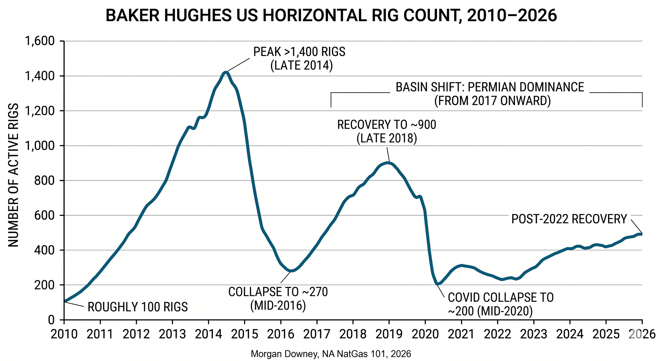
The shift from cable tool to rotary to triple-stand to walking is 120 years of operational history compressed. Cable-tool drilling, the Pennsylvania-style percussion technique that drilled most of the early oilfields and Edwin Drake’s first well at Titusville in 1859, dropped a heavy bit on a cable to crush rock by impact. Rotary drilling, introduced at the Spindletop boom in 1901 and dominant by the 1920s, rotated a bit on a drill string and circulated mud to lift cuttings to surface. Triple-stand rigs, common from the 1980s onward, handled drill pipe in 90-foot stands of three joints rather than the earlier 30-foot single joints, tripling the speed of trips. Walking rigs are the fourth wave, designed specifically for multi-well pad development and now standard across every major US shale basin.
Day rates moved with the cycle. A Tier-1 horizontal land rig, the modern AC variable-frequency-drive walking rig with a top drive and a 7,500 psi mud system, ran roughly $20,000 to $25,000 per day in the late 2010s downturn, climbed to roughly $35,000 to $45,000 per day in the post-2022 recovery, and ran roughly $30,000 to $40,000 per day in late 2024 as activity moderated. Older rigs trade at substantial discounts; spot pricing on a non-walking, mechanical-driven rig can run roughly half the Tier-1 rate. The full operating cost of a rig to the operator is roughly twice the day rate once contract labor, fuel, drill pipe rental, and bits are added in.
The crew on a modern rig is small. A driller runs the controls from an enclosed cabin overlooking the rig floor. A derrickhand works the upper monkeyboard during trips, racking pipe in the derrick. A motorhand and two floorhands handle pipe at the rig floor. A leasehand works the catwalk and yard. Twelve-hour shifts, two shifts per day, fourteen days on and fourteen days off in most modern rotations. A directional driller and a mud engineer ride the rig under separate service contracts: the directional driller monitors tool face and trajectory through the curve and the lateral, and the mud engineer adjusts fluid composition as the well penetrates different formations.
A typical modern Permian or Marcellus shale well now reaches total depth in 10 to 15 days from spud to rig release. Operator records below 7 days exist for short-lateral pad wells and have been disclosed in investor presentations, particularly by EQT in the Marcellus and by Diamondback Energy in the Permian.
The Horizontal Well
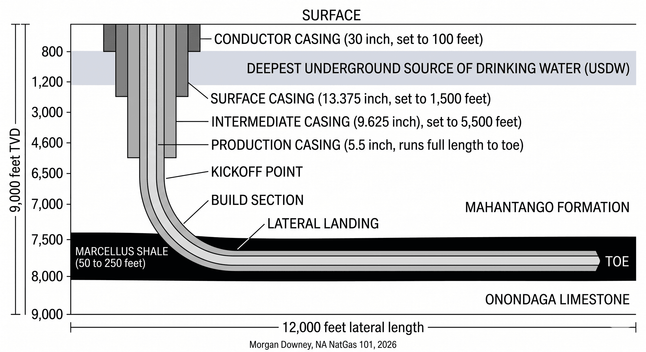
A modern horizontal shale well has three sections. The vertical section runs from surface to the kickoff point. The build curve, also called the build section, turns the wellbore from vertical to horizontal over a few hundred to a few thousand feet of measured depth. The lateral runs through the producing zone for thousands of feet at near-horizontal inclination.
Kickoff point depth is set 500 to 1,000 feet above the target landing depth in the producing zone. The choice depends on the build rate the directional driller can sustain, the geometry of the lateral landing, and the casing program. A higher kickoff point gives the build curve more vertical room to land softly into the producing zone, which matters when the producing interval is thin. A lower kickoff point shortens the build section but requires a more aggressive build rate and tighter tolerance on landing depth.
Build rates in modern shale drilling run 6 to 12 degrees per 100 feet of measured depth, expressed as the dogleg severity. A 9-degree-per-100-foot build from a 6,500 foot kickoff requires about 1,000 feet of measured depth to reach 90 degrees of inclination. The bit and bottomhole assembly during the build differ from the vertical-section assembly. A steerable mud motor or a rotary steerable system provides directional control while the drill string rotates from surface, and a measurement-while-drilling sub embedded just behind the bit reports inclination and azimuth back to surface in near-real-time.
The lateral itself runs through the producing zone. The geometry can be toe-up, with the toe of the lateral, the deep end, shallower than the heel, the bend out of the build curve, or toe-down, with the toe deeper. Toe-up geometries are preferred where natural drainage of completion fluid out of the lateral matters, particularly for liquids-rich plays. Toe-down geometries may be chosen where the producing zone dips downward across the leased acreage, or where reservoir-engineering concerns favor draining gas from the toe back toward the heel.
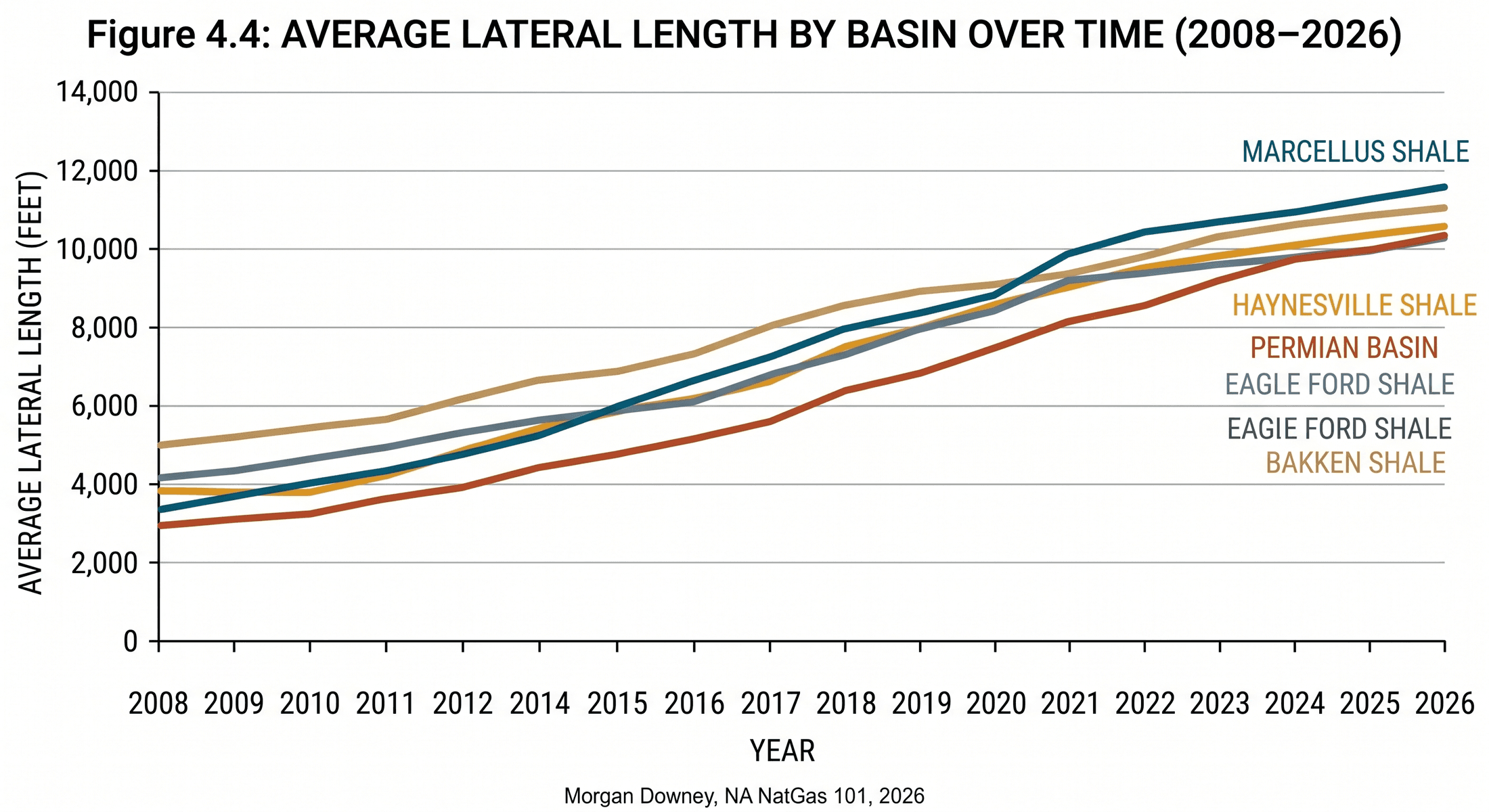
Lateral lengths have grown steadily across all US shale basins. The first economic Marcellus laterals in 2008 ran 2,500 to 4,500 feet. Typical Marcellus laterals in 2014 ran 5,500 to 7,000 feet. Typical Marcellus laterals in late 2024 ran 9,500 to 12,000 feet, with EQT, Antero, and Coterra each disclosing 3-mile laterals of 15,000 feet or longer in their core acreage. Haynesville laterals ran 5,000 to 6,000 feet at the play’s launch in 2008 to 2010, climbed to 7,500 to 9,500 feet by 2018, and run 9,500 to 12,500 feet in late 2024, with Comstock and Aethon disclosing 15,000-foot laterals in core acreage. Permian laterals run shorter on average because sub-basin acreage breaks up at the surface; typical Wolfcamp laterals run 8,000 to 11,000 feet, with extended laterals on dedicated long-lateral acreage. Eagle Ford laterals run 6,000 to 8,500 feet.
The economic drive for longer laterals is straightforward. Capital cost per foot of lateral falls as the rig amortizes its mobilization, surface casing, and intermediate casing over a longer producing section. Estimated ultimate recovery per foot of lateral is roughly stable in core acreage, so the operator captures more reserves per dollar of capital. The constraints are friction in the wellbore, the tensile rating of the drill pipe at long measured depths, the practical limits of pumping completion fluid the full length of the lateral during the frac, and the geometry of the leasehold. Marcellus operators in the Pennsylvania core have assembled continuous units large enough for 3-mile laterals; Permian operators in West Texas have not, except in dedicated long-lateral acreage trades like the ones EOG and ExxonMobil have publicized.
The push to 3-mile and 4-mile laterals is the current frontier. Whether the unit-economics improvement holds at those lengths depends on whether completion design and drilling efficiency keep pace, and on whether the marginal foot of lateral contacts producing rock at the same intensity as the heel and the middle. Operator data through 2024 suggests that economics improve out to roughly 12,000 to 15,000 feet and flatten beyond that, with operator-specific results that do not converge on a single conclusion.
MWD, LWD, and Geosteering
Measurement-while-drilling sensors live in a sub at the top of the bottomhole assembly, a few feet to a few tens of feet behind the bit. The sensors measure inclination (the angle of the wellbore from vertical), azimuth (the compass direction the wellbore is pointing), and gamma ray (the natural radioactivity of the formation immediately around the bit). Gamma ray distinguishes shale, with high gamma counts from naturally occurring potassium, uranium, and thorium in the clay minerals and organic matter, from limestone, dolomite, and clean sandstone, all of which read lower.
Data transmission from the MWD sub to the surface uses mud-pulse telemetry. The MWD sub modulates the pressure of the drilling mud column with a hydraulic valve, sending a binary stream of pressure pulses up the mud column to a transducer at the standpipe. The data rate is slow, typically 1 to 6 bits per second for standard mud-pulse systems, with high-data-rate variants pushing 10 to 40 bps. It is sufficient for the inclination, azimuth, and gamma ray data the directional driller needs at survey stations every 30 to 90 feet of measured depth.
Logging-while-drilling tools extend the MWD measurement set. LWD tools add resistivity, which distinguishes hydrocarbon-bearing rock from water-bearing rock by their different electrical conductivities, plus bulk density, neutron porosity, photoelectric factor, and acoustic measurements similar to the ones wireline logging tools acquire after drilling. Image-logging LWD tools generate a borehole image showing fractures, bedding planes, and lithology variations around the bore wall. The data still transmits via mud-pulse, with higher-rate options like electromagnetic telemetry, which transmits through the formation, used in specific applications.
Geosteering is the combined activity of MWD, LWD, and a geosteering geologist who watches the data come back from surface and adjusts the wellbore trajectory in near-real-time to keep the lateral inside the producing zone. The geologist works from a pre-drill cross-section, built from offset wells and seismic, that predicts the depth and structure of the producing zone along the planned lateral path. As the bit advances and gamma ray and resistivity data come back, the geologist updates the cross-section and adjusts the target trajectory if the producing zone is shallower or deeper than predicted, or if the bedding has steepened or flattened.
The directional driller translates the geologist’s instructions into tool-face commands at the bit. A steerable mud motor has a small bend angle, typically 1 to 3 degrees, that produces a slight deflection from the borehole axis when the bit is rotated by mud flow alone with the drill string held stationary, a configuration called sliding mode. When the drill string rotates from surface, called rotating mode, the bend orientation averages out and the wellbore drills straight. Alternating between sliding and rotating mode steers the wellbore. Rotary steerable systems use internal pads that push against the borehole wall to steer continuously while rotating, and they produce smoother wellbores and faster drilling than steerable motors at higher cost per foot.
The reason geosteering matters is that the producing zone in most shale plays is thin. The Middle Devonian Marcellus has a productive section of 50 to 250 feet across the Pennsylvania core, but the most organic-rich and most productive interval inside that section is often only 30 to 60 feet thick. A 12,000-foot lateral that drifts 20 feet vertical out of the productive interval over 1,000 feet of measured depth has left the most productive rock for the lower-quality rock above or below. The economic difference can be 30 to 50 percent of estimated ultimate recovery for that section.
Casing, Cementing, and the BOP Stack
Casing is the steel pipe that lines the wellbore. Cement fills the annulus between the casing and the borehole wall. Together they isolate the wellbore from the surrounding formations, prevent communication between zones at different pressures, and protect freshwater aquifers from hydrocarbons or completion fluids. A modern shale well runs four casing strings.
The conductor casing is the largest-diameter pipe, typically 20 to 30 inches in outside diameter, set during pad construction to a depth of 60 to 120 feet. It supports the rig substructure and prevents the surface formation from caving into the borehole during the early shallow drilling. It is set by driving with a pile hammer or by drilling and cementing a short section.
The surface casing, typically 13.375 inches in outside diameter for shale wells, is set after the rig drills past the deepest underground source of drinking water, a depth that ranges from 300 feet in some Permian sub-areas to 2,500 feet in some Appalachian sub-areas. The surface casing is cemented from total depth back to surface, sealing the freshwater zone away from anything deeper. Most state oil-and-gas regulators require pressure testing of the surface casing and cement bond logging before the rig drills the next section.
The intermediate casing, typically 9.625 inches in outside diameter, is set after the rig drills through any high-pressure formations or lost-circulation zones above the producing interval. The intermediate casing is cemented either to surface or to a level above the surface casing shoe, with the operator choosing based on regulatory requirements, the formations being isolated, and the cost-benefit of the additional cement volume.
The production casing, typically 5.5 inches in outside diameter for shale wells, is run after the lateral is drilled to total depth. It is cemented along the full length of the lateral and the build curve, providing the conduit through which the well will produce gas after the cement has set and the well has been hydraulically fractured. The cement bond is critical: a poorly cemented production casing in a shale lateral can let frac fluid migrate out of the intended fracture stage and along the cement column, compromising stage isolation and reducing the productivity of the well.
The blowout preventer stack, the BOP, sits at the wellhead during drilling and completion. It is an assembly of large hydraulically operated valves designed to seal the well against an uncontrolled influx of formation fluid (a kick) that the mud column cannot contain. A typical land-rig BOP stack includes annular preventers (rubber elements that close around the drill pipe), pipe rams (steel rams that seal around a specific pipe diameter), shear rams (rams that cut the drill pipe and seal the bore), and blind rams (rams that seal an open hole when no pipe is in the well). Pressure ratings of 5,000, 10,000, and 15,000 psi cover most onshore applications, with the 10,000 psi rating standard for shale work. The BOP is tested before each casing string is run and on a schedule that matches the operator’s well-control management system.
The Macondo blowout on Tue April 20, 2010, which killed 11 men on the Deepwater Horizon and discharged roughly 3.2 million barrels of oil into the Gulf of Mexico over 87 days (the federal court finding in US v. BP, 2015), was caused in part by a failed cement bond at the bottom of the production casing combined with a BOP that did not close as designed when the kick reached the rig. The accident reshaped offshore well design and BOP testing protocols across the industry. The same engineering principles apply onshore. Cement integrity and BOP function are not optional layers; they are the difference between a controlled well and a Macondo.
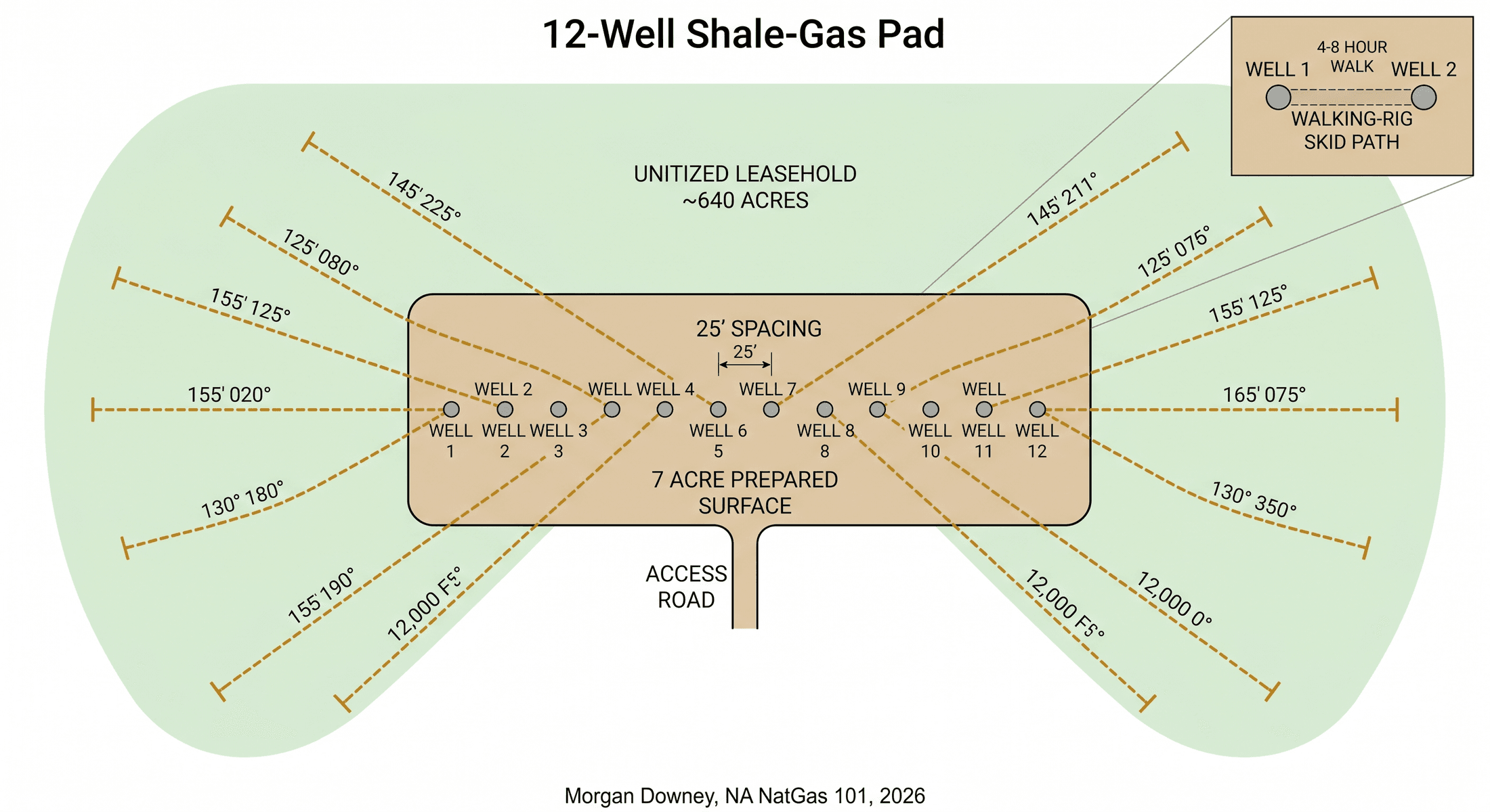
The Pad: Drilling Twelve Wells from One Location
The multi-well pad is the unit that defines modern shale economics. A single prepared pad of 5 to 10 acres hosts 4 to 16 surface locations, each well kicking off in a different azimuth so that the laterals fan out beneath the surrounding leasehold like the spokes of a wheel.
Pad construction begins months before the first spud. The operator levels and compacts a graded surface, installs containment liners against fluid spills, builds access roads sized for the heavy haul trucks that deliver casing, sand, and water, sets surface conductor pipe at each surface location, and runs power and produced-water gathering lines into the pad. The capital expenditure on the pad itself runs roughly $1 to $3 million for a 12-well location, a cost amortized across the wells drilled from it.
The drilling sequence on a pad is choreographed. The first rig may drill the vertical section and surface casing on every well in the row before any laterals are landed, a batch approach that lets the same crew run repetitive operations efficiently. A second rig moves in to drill the build curves and laterals while the first rig batch-drills the verticals on the next pad. The batch approach saves rig time at the cost of front-loading capital. Some operators reverse the sequence and drill each well in full before walking to the next location, a choice that flattens the capital profile at the cost of slower repetition.
Walking rigs are the operational breakthrough that made the multi-well pad practical. The hydraulic skid system moves the entire 200-foot rig assembly, the substructure, and the drilling control systems 25 to 30 feet sideways across the pad in 4 to 8 hours. Without walking systems, a rig has to be partially rigged down, transported on heavy haul trucks across the access road, and rigged back up at the next location, a 2 to 5 day cycle that consumes day-rate cost and crew time. The walking move replaces that cycle with a single overnight shift.
The completion advantage compounds the drilling advantage. After all wells on a pad are drilled and cased, completions crews come in and frac the wells in a staggered pattern called zipper-fracking, where adjacent wells are fractured in alternating stages so that the fracture network of one well opens additional pathways into the adjacent reservoir while the second well is being pumped. Zipper-fracking improves completion efficiency, increases stimulated reservoir volume per stage, and lowers the per-well completion cost. It can also worsen parent-child fracture interference if the timing is mismanaged. The full discussion sits in Chapter 7.
Stacked-pay basins multiply the pad effect. The Permian’s Wolfcamp shale has multiple producing benches, labeled Wolfcamp A, B, C, and D in some sub-areas, each at a different depth and each potentially producing oil with associated gas under separate completion designs. A single pad can drill wells targeting two or three benches, doubling or tripling the producing volume from the same surface footprint. The Marcellus and the Utica are stacked across most of the Appalachian Basin, and operators in eastern Ohio and southwest Pennsylvania routinely co-develop both. The Haynesville and the deeper Bossier are stacked in parts of East Texas and northern Louisiana, with growing co-development through the 2020s.
Susquehanna County, Pennsylvania, 2019
In the spring of 2019, on a 12-well pad in Susquehanna County, Pennsylvania, an EQT crew drilled a 19,000-foot Marcellus well from spud to rig release in under seven days. Two years earlier the same operator’s average had been 14 days. Three years earlier it had been 22 days. Most of the improvement did not come from any single technology. It came from the cumulative effect of a thousand small refinements: better PDC bit designs that lasted longer in the abrasive Marcellus carbonate stringers, faster connections from automated catwalks and iron roughnecks, optimized mud chemistry that reduced friction in the long laterals, slip-and-cut programs on drill pipe that prevented fatigue failures, and the steady accumulation of operational data from thousands of wells that let the operator’s drilling engineers identify exactly which decision points cost the most time.
The 22-day-to-7-day compression is the productivity story of US shale at the rig level. It happened in the Marcellus, in the Haynesville, in the Permian, and in the Bakken on roughly the same timeline. The operators that built systematic learning organizations around their drilling programs lowered well costs faster than the operators that did not, and over the decade the cost gap between best-quartile and worst-quartile operators in any given basin reached a factor of two.
What a Well Costs
Drilling-only cost on a modern shale well is the rig day rate over the spud-to-rig-release period plus the consumables and services the operator buys directly from third-party vendors. Completion cost is a separate item, covered in Chapter 7. The drilling-only components are roughly proportionate across basins.
Rig contract: 30 to 40 percent of drilling-only cost. A 15-day rig contract at $35,000 per day, the late-2024 Tier-1 horizontal walking-rig spot rate, runs about $525,000 in day rate alone, plus standby and fuel surcharges that add another 10 to 20 percent on top.
Casing and cement: 20 to 30 percent. A 12,000-foot Marcellus well runs roughly 3,500 feet of 13.375-inch surface casing, 3,500 feet of 9.625-inch intermediate casing, and 19,500 feet of 5.5-inch production casing across the vertical, build, and lateral sections. Casing pricing varies with steel-mill capacity and tariff regimes; Section 232 tariffs on imported steel imposed in March 2018 raised domestic OCTG (oil country tubular goods) prices materially.
Drilling fluids: 8 to 12 percent. A 19,500 measured-depth well with high-density mud through the lateral consumes 5,000 to 10,000 barrels of drilling fluid over the life of the well, including fluid lost to formation, fluid recirculated through the system, and disposal of cuttings.
Bits and downhole tools: 3 to 7 percent. A modern shale well runs 1 to 3 polycrystalline-diamond-compact bits depending on rock hardness and bit life, plus a steerable mud motor or rotary steerable assembly rented under day-rate or footage terms.
MWD and directional services: 5 to 10 percent. The directional driller and the MWD/LWD service contractor charge a daily rate plus footage in the lateral, typically running $4,000 to $8,000 per day combined. Halliburton, SLB (formerly Schlumberger), Baker Hughes, and Weatherford provide most of the directional services in US shale; smaller specialists handle the rest.
Location preparation and water: 8 to 15 percent. Pad construction, access roads, conductor pipe, and water sourcing for cement and drilling mud. Water sourcing is a meaningful component in arid basins like the Permian, where freshwater is scarce and operators source from depleted municipal supplies, brackish aquifers, or commercial water suppliers.
Drilling-only cost ranges in late 2024, by representative basin and lateral length, run roughly:
- Dry-gas Marcellus, 12,000-foot lateral: $3.5 to $5 million
- Haynesville, 10,000-foot lateral: $5 to $7 million
- Permian Wolfcamp, 12,000-foot lateral: $4 to $5.5 million
- Bakken, 10,000-foot lateral: $3.5 to $5 million
These are drilling-only figures. Total well cost, drilling plus completion, runs roughly two to three times the drilling-only number across most plays, with completion the dominant cost item.
Permian drilling costs trended sharply downward from 2014 to 2020 as walking rigs displaced rigid rigs, lateral lengths grew, operators learned to drill faster with fewer non-productive-time hours, and competition among contractors compressed margins through the 2015 to 2016 and 2019 to 2020 downturns. Costs trended back upward from 2022 to 2024 as steel, labor, and trucking costs rose with general inflation, and the underlying economics absorbed the added cost without flinching as long as oil prices stayed above $70.
Haynesville drilling costs have been persistently higher than other dry-gas plays because of the depth, with true vertical depths of 10,500 to 13,500 feet, the bottomhole temperature, which raises drilling-fluid costs and limits bit life, and the high-pressure formation environment, which requires heavier casing strings and more conservative cementing programs. The depth and the heat are the two facts the geology produces, and the cost structure inherits both.
Drilling produces a wellbore. The economics of the modern shale well do not begin until that wellbore is hydraulically fractured, and Chapter 7 turns to the completion.