Geology and Origins
Conventional vs unconventional gas, source rock vs reservoir, and a basin-by-basin tour of Marcellus, Permian, Haynesville, Anadarko, Bakken, Eagle Ford, Niobrara, and Montney.
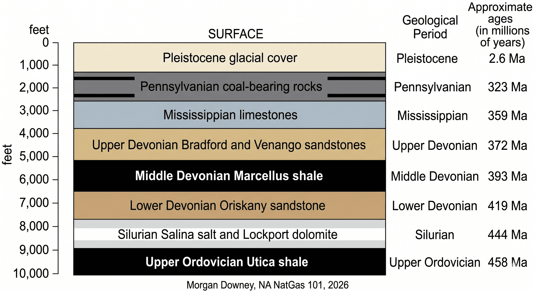
The well was called Renz #1. Range Resources spudded it in the summer of 2003 in Cross Creek Township, Washington County, Pennsylvania, about 30 miles southwest of Pittsburgh, on farmland that had been producing a trickle of shallow conventional gas since the 1920s. The original target was the Oriskany sandstone at roughly 8,000 feet, a respectable Lower Devonian reservoir that had paid out conventional wells across southwestern Pennsylvania for decades. The Oriskany came in dry.
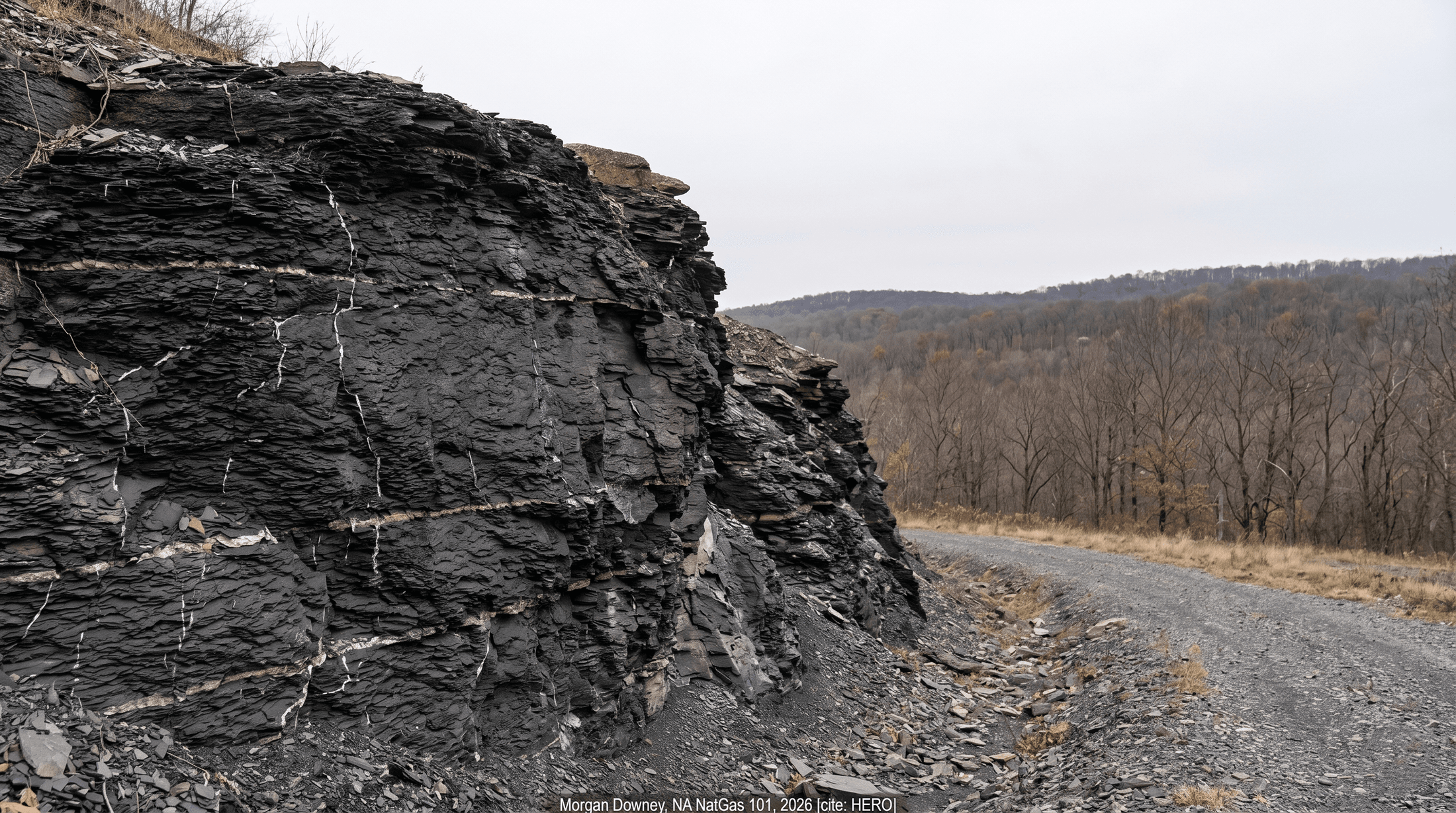
What changed everything was what Range did next. Bill Zagorski, the geologist running the play for Range, had spent the previous year studying the Barnett Shale work that Mitchell Energy and then Devon were doing in the Fort Worth Basin. Zagorski looked at the cuttings Renz had pulled through the Marcellus interval, a black, organic-rich Middle Devonian shale roughly 50 to 250 feet thick that every Pennsylvania driller had punched through and ignored for a hundred years. The total organic carbon in those cuttings ran higher than anything published for the basin. The setting matched the Barnett. Range completed the well as a vertical slickwater frac in the Marcellus interval in 2004 and kept the result quiet for the next three years, leasing roughly 1.4 million acres across Pennsylvania and West Virginia at conventional-play rates.
When Range disclosed the play at an industry conference in October 2007, Pennsylvania mineral rights began trading at five to ten times what they had cost two years earlier. By 2008 the Marcellus had a name on Wall Street. By the mid-2020s it was the largest gas-producing region in the United States and the second largest in the world, behind only the North Field that Qatar and Iran share under the Persian Gulf.
The black shale Zagorski was looking at had been deposited 390 million years before, on the floor of a shallow inland sea, on a continent that did not yet have land plants tall enough to be called trees.
Conventional and Unconventional Gas
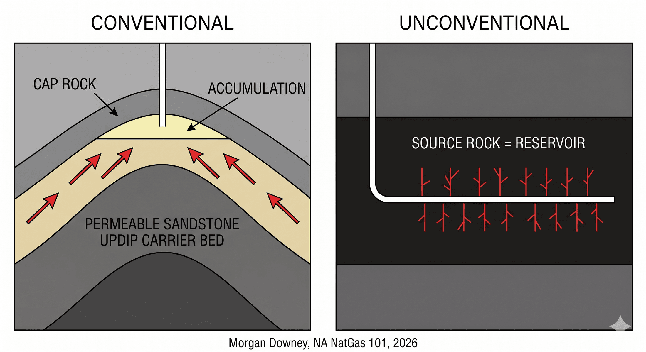
A conventional gas reservoir has three things. Source rock that generated the gas, a permeable reservoir rock the gas migrated into, and an impermeable trap that stopped it from escaping. The textbook example is the Hugoton Field, the giant Permian-age gas accumulation across western Kansas, the Oklahoma Panhandle, and the Texas Panhandle, which has produced more than 70 trillion cubic feet of gas since its discovery in 1922 and is still flowing. Source rock generated the gas, dolomite and limestone reservoirs hosted it, an evaporite seal trapped it, and vertical wells with conventional perforations let it out.
An unconventional reservoir collapses two of those three steps into one. The source rock is the reservoir. The gas never migrated. It sits where it was generated, dispersed through nanometer-scale pores and natural fractures in shale or tight siltstone with permeability measured in nanodarcies, eight orders of magnitude lower than a producing sandstone. A vertical well in that rock produces almost nothing because the gas cannot reach the bore. A horizontal well several thousand feet long, hydraulically fractured at intervals of 100 to 300 feet, creates a network of artificial fractures that contact enough of the source rock to make the well economic.
The geological term for low-permeability gas plays is tight gas. Industry usage shifted in the late 1990s. Coalbed methane, deep tight sandstones, and shale gas were lumped together as unconventional, partly to distinguish them from the legacy fields they were replacing, partly to slot into regulatory and tax categories that treated them differently. The Section 29 production tax credit, written into the Crude Oil Windfall Profit Tax Act of 1980, subsidized non-conventional gas in the United States through the early 1990s and was a meaningful contributor to the early Barnett and to San Juan coalbed methane economics.
After 2010 the term unconventional became a misnomer. By the early 2020s, more than three quarters of US gas production came from shales and tight formations. The unusual case is now a vertical well into a high-permeability sandstone. The categories survive in regulatory filings and in the pricing of services contracts, but the geology that defines them no longer marks the edge of the industry. It defines the center.
How Gas Formed
Most North American gas was generated in source rocks deposited during three windows of geological time. The Devonian, about 419 to 359 million years ago. The Mississippian and Pennsylvanian, about 359 to 299 million years ago. And the Cretaceous, about 145 to 66 million years ago. Each window corresponds to a period when the continent was partly submerged, sea bottoms were warm and oxygen-poor, organic-rich mud accumulated faster than it could decay, and conditions favored the preservation of plant and microbial debris.
Buried sediment compacts and heats at roughly 25 degrees Celsius per kilometer of depth, the geothermal gradient. Organic matter in the buried mud, mostly algal and microbial in origin, transforms into a waxy intermediate called kerogen. As burial continues, the kerogen passes through the oil window between roughly 60 and 120 degrees Celsius, then into the gas window above 120 degrees, where longer hydrocarbon chains crack into shorter ones. By around 200 degrees Celsius the only hydrocarbon left is methane, and the source rock is described as overmature. Thermogenic gas is the product of this thermal cracking.
A second pathway is biogenic. Methanogenic archaea in shallow, anaerobic environments produce methane by metabolizing organic matter at near-surface temperatures. Most landfill gas is biogenic. So is most of the methane in the very shallow Antrim Shale of Michigan, where biogenic generation is still active in the modern subsurface, and a meaningful share of the gas produced from the shallow coal seams of the Powder River Basin. Biogenic gas is almost pure methane, with little ethane and almost no heavier hydrocarbons.
Whether gas migrates depends on the seal above the source rock. In conventional plays the gas leaves the source rock, moves up dip through carrier beds, and pools against a structural or stratigraphic trap. In shales and tight reservoirs there is no migration; the gas stays in place and is recovered only by hydraulic fracturing.
The composition of the gas at the wellhead reflects the maturity of the source. A young, oil-window source produces wet gas with significant ethane, propane, butane, and pentane, the natural gas liquids. A deep, hot, overmature source produces dry gas, more than 95 percent methane. The Marcellus in northeast Pennsylvania is dry. The Marcellus in southwest Pennsylvania, slightly shallower and slightly less mature, is wet. Same formation, two compositions, two netbacks.
The North American Basins
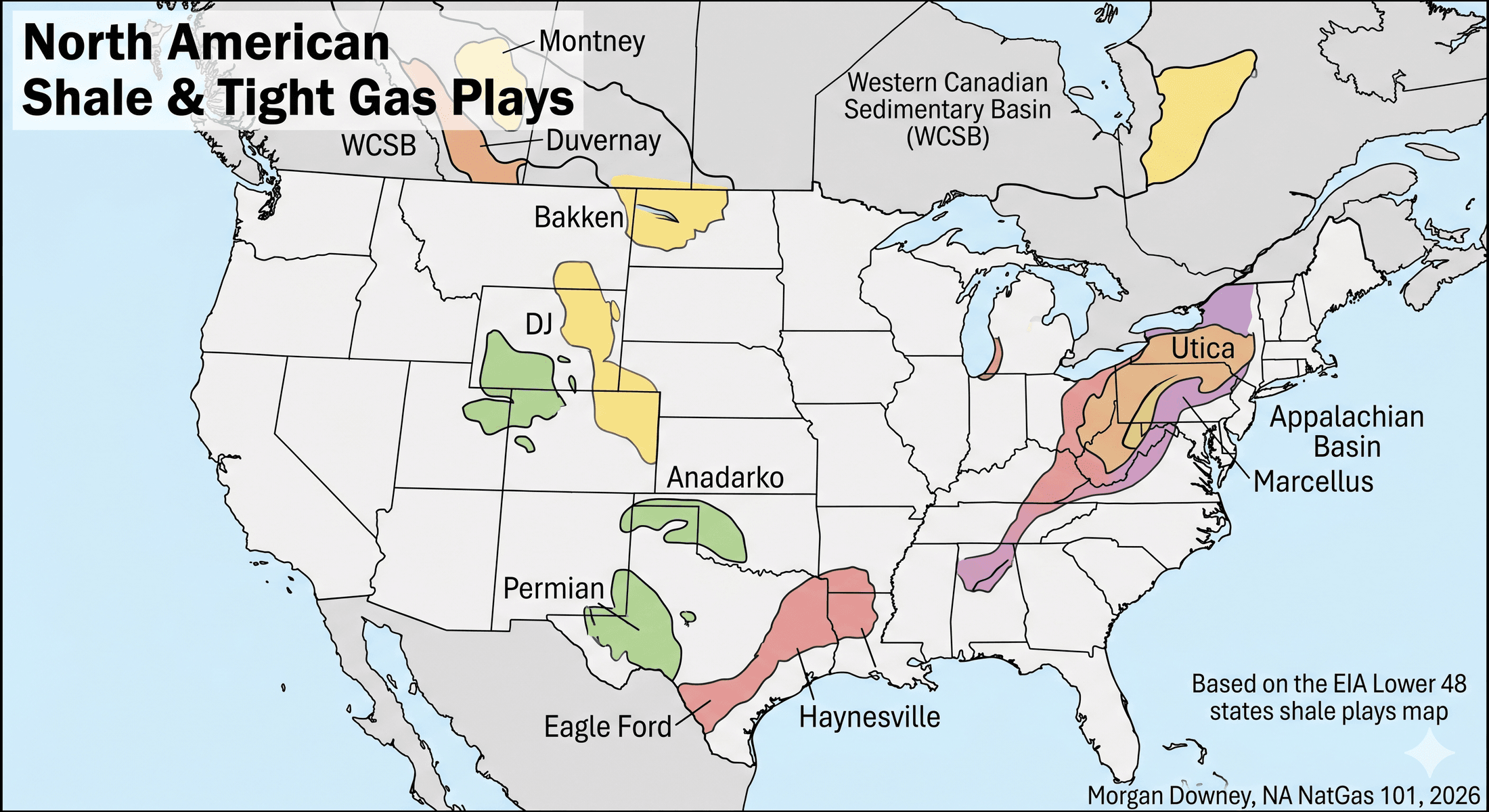
Appalachian Basin: Marcellus and Utica
The Appalachian Basin is the largest gas-producing region in North America. The play covers most of Pennsylvania, West Virginia, and eastern Ohio, with smaller extensions into New York, Maryland, and Virginia. Two stacked source rocks dominate. The Middle Devonian Marcellus shale, deposited around 390 million years ago, lies between roughly 4,000 and 9,000 feet below the surface across the productive fairway. The Upper Ordovician Utica shale, deposited around 450 million years ago and 100 to 200 million years older, sits 2,000 to 4,000 feet below the Marcellus across most of the basin and is the play of choice in eastern Ohio where the Marcellus thins.
Three sub-regions matter. The northeast dry-gas core in Bradford, Susquehanna, Tioga, and Wyoming counties of Pennsylvania holds the most thermally mature, highest-flow-rate dry-gas wells in the basin, with initial production routinely above 20 million cubic feet per day for top wells. The southwest wet-gas core, in Washington and Greene counties of Pennsylvania and the West Virginia panhandle, produces gas with 1,200 to 1,300 Btu per cubic foot heating value because of the ethane and propane content, which improves netback when NGL prices are firm. The Ohio Utica, centered in Belmont, Monroe, and Jefferson counties, is the third leg, again split into wet and dry windows.
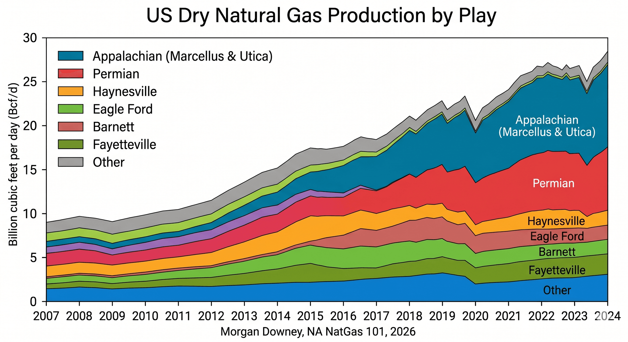
Total Appalachian gas production runs in the range of 35 billion cubic feet per day, of which the Marcellus alone accounts for roughly 28 to 30 Bcf/d. The basin’s structural problem is takeaway. New York banned hydraulic fracturing in 2014, which closed off a natural northeastern delivery corridor. Pipeline approvals across Pennsylvania and into the Mid-Atlantic and Southeast have moved at a glacial pace. Marcellus dry gas in northeast Pennsylvania regularly trades $0.50 to $1.50 per MMBtu below Henry Hub, and producers’ netbacks track the basis as much as they track the headline.
Permian Basin
The Permian Basin sits beneath West Texas and southeastern New Mexico. Two sub-basins, the Delaware to the west and the Midland to the east, are separated by the Central Basin Platform, a buried ridge of older carbonates. The play is overwhelmingly an oil play. The Wolfcamp, Bone Spring, Spraberry, and Avalon formations, all of Permian age (roughly 299 to 252 million years ago), produce oil with associated gas as a byproduct. In a stacked Wolfcamp well, every barrel of oil arrives with roughly 1,500 to 5,000 cubic feet of gas, depending on sub-area and depth. The gas is wet, with significant ethane, propane, and butane content.
Gross gas production from the Permian runs around 25 billion cubic feet per day, almost all of it associated with oil drilling. The USGS 2018 assessment of the Wolfcamp and Bone Spring estimated 46.3 billion barrels of oil and 281 trillion cubic feet of gas as technically recoverable, the largest continuous oil and gas assessment USGS has ever published in the United States.
The economic distinction that matters is that Permian gas production is set by the oil rig count, not by the gas price. When WTI is at $80 a barrel, operators drill, oil flows, and gas flows whether Henry Hub is at $4 or at $1. This is why the Waha hub in West Texas has traded at negative prices repeatedly since 2019 when pipeline takeaway has hit its limits. The geology produces the molecule whether the market wants it or not.
Haynesville Shale
The Haynesville sits beneath East Texas and North Louisiana, with the deepest, hottest, most productive portion concentrated under De Soto, Sabine, Bossier, Caddo, Red River, and Panola parishes. The source rock is Upper Jurassic, deposited around 155 million years ago in a restricted marine basin during the early opening of the Gulf of Mexico. Productive depths run 10,500 to 13,500 feet, deeper than almost any other US shale play. Bottom-hole temperatures exceed 300 degrees Fahrenheit and reach above 400 in the deepest sections.
Three things follow from the depth and heat. The source rock is overmature, so the gas is dry, typically 96 to 98 percent methane with almost no NGL content. The reservoir is overpressured, with formation pressures running 0.85 to 0.95 psi per foot of depth, well above the 0.43 psi-per-foot hydrostatic gradient. That overpressure drives high initial production rates, with top wells exceeding 25 to 35 million cubic feet per day for the first 30 days. And the wells are expensive, with completed costs in the range of $12 to $16 million for a 10,000 to 15,000 foot lateral.
Haynesville production runs in the 16 to 18 Bcf/d range. The basin’s economic role is as the swing dry-gas play. When Henry Hub firms above roughly $3.50 per MMBtu the Haynesville rig count rises within months and production responds. When Henry Hub falls below $2.50, the rig count drops and base decline does the work.
Anadarko Basin: SCOOP, STACK, and the Woodford
The Anadarko Basin underlies most of western Oklahoma, with extensions into the Texas Panhandle and southern Kansas. Two unconventional plays dominate the recent history. SCOOP, the South Central Oklahoma Oil Province, sits in Grady, Stephens, Garvin, and Carter counties along the deeper southern flank of the basin and produces from the Upper Devonian to Lower Mississippian Woodford shale and the overlying Springer formation. STACK, the Sooner Trend Anadarko Canadian Kingfisher play, sits in Kingfisher, Canadian, Blaine, and Major counties to the north and produces from the Mississippian Meramec and Osage limestones, with the Woodford as the underlying source rock.
The Woodford is the same source rock as the Bakken in the Williston Basin and the Barnett in the Fort Worth Basin, deposited across a broad swath of the continent during the Late Devonian to Early Mississippian transition, roughly 360 million years ago. Productive depths run 10,000 to 15,000 feet for SCOOP, shallower for STACK, and the gas is wet with substantial NGL content in the SCOOP condensate window.
Anadarko gas production runs around 6 to 7 Bcf/d, well below its 2018 peak. The basin lost momentum in the late 2010s when several large operators ran into well-spacing problems, parent-child fracture interference reduced expected EURs, and capital rotated toward the Permian. The geology has not changed; the economics have.
Bakken
The Bakken sits in the Williston Basin under western North Dakota, eastern Montana, and southern Saskatchewan. The source rock is Late Devonian to Early Mississippian, roughly the same age as the Woodford, and the productive interval consists of the Upper and Lower Bakken shales sandwiching a Middle Bakken siltstone reservoir, with the deeper Three Forks formation often completed in the same wells. Productive depths run 8,500 to 11,500 feet.
The Bakken is an oil play. Wells produce 700 to 1,500 barrels per day of oil during the first month, plus roughly 1 to 3 million cubic feet per day of associated gas. North Dakota gas production runs around 3 Bcf/d. The Bakken’s structural problem has historically been gas flaring. Gathering and processing infrastructure lagged the oil-driven drilling boom of the early 2010s, and at the peak around 2014 about a third of North Dakota’s produced gas was being flared at the wellhead. The North Dakota Industrial Commission imposed flaring caps that year, infrastructure caught up, and flared volumes have dropped substantially since, though the ratio still spikes when new pads come online ahead of gathering connections.
Eagle Ford
The Eagle Ford runs across South Texas in a 50-mile-wide band that arcs from the Mexican border northeast through Maverick, Dimmit, La Salle, McMullen, Karnes, and DeWitt counties. The source rock is Late Cretaceous, deposited about 95 million years ago in a marine basin south of what was then the Western Interior Seaway. The play has three distinct windows running northwest to southeast as the formation deepens. A shallower oil window in the north, a wet gas and condensate window through the middle, and a deep dry gas window along the southern edge near the border.
Productive depths run 4,000 to 8,000 feet in the oil window, 10,000 to 13,000 feet in the dry gas window. Petrohawk Energy drilled the first well that proved the Eagle Ford could produce at scale, in La Salle County in 2008. By 2014 the Eagle Ford was producing more than 1.4 million barrels per day of oil and 6 Bcf/d of gas; production has since stabilized below those peaks as the most prolific acreage was drilled out.
The condensate window matters disproportionately for the gas market. Eagle Ford condensate is light, with API gravity above 50, and the wells produce a high cut of NGLs along with the gas. That liquids stream subsidizes the gas economics in a way that pure dry-gas plays cannot match.
Niobrara and the DJ Basin
The Denver-Julesburg Basin underlies northeastern Colorado, with extensions into Wyoming and Nebraska. The unconventional play of record is the Niobrara, a Late Cretaceous chalk formation deposited around 85 million years ago, with the Codell sandstone as a secondary target immediately below. Productive depths in the Wattenberg Field, the core area in Weld County north of Denver, run 6,500 to 8,500 feet.
The DJ is an oil-prone basin with substantial associated gas and NGL output. Total basin gas production runs around 1.5 to 2 Bcf/d. The structural overhang in the DJ is regulatory. Colorado passed Senate Bill 19-181 in April 2019, shifting the priority of the state’s oil and gas regulator from fostering production to protecting public health and the environment, and tightened setback rules from occupied buildings. New permits became slower and more expensive. Operators that had built businesses around rapid Wattenberg drilling adjusted. The geology stayed the same; the regulatory cost of accessing it changed.
Western Canadian Sedimentary Basin: Montney and Duvernay
The Western Canadian Sedimentary Basin, WCSB, underlies most of Alberta, northeast British Columbia, and southwestern Saskatchewan. Two unconventional plays carry the modern gas story. The Montney is a Lower Triassic siltstone, deposited around 245 million years ago along the western margin of what was then the supercontinent Pangea. The Duvernay is a Late Devonian shale, deposited around 375 million years ago, and is also the historic source rock for the Devonian reef oil pools of central Alberta that fueled the Leduc discovery in 1947.
The Montney is geographically vast, covering more than 50,000 square miles across northeast British Columbia and northwestern Alberta, and is unusual in that it is closer to a tight siltstone than to a true shale. Productive depths run 5,500 to 13,000 feet. The play produces wet gas with high condensate yields, a critical economic feature in a basin where condensate is in short supply for diluting bitumen for pipeline transport. Montney gas production runs around 7 to 8 Bcf/d and accounts for the majority of WCSB gas growth in the past decade.
The Duvernay is smaller, deeper, and more liquids-rich than the Montney, with productive depths around 11,000 to 14,000 feet. Production runs around 1 Bcf/d. Both plays feed into the AECO pricing point in southern Alberta and, increasingly, into the LNG Canada export terminal at Kitimat on the Pacific Coast, which began commercial Train 1 operations in 2025 and gives WCSB gas its first significant ocean-going outlet.
Coalbed Methane and Tight Gas
Two earlier waves of unconventional production deserve a paragraph each, because they shaped the infrastructure and the workforce that the shale revolution inherited.
Coalbed methane was the 1990s growth story. The San Juan Basin, straddling the Colorado-New Mexico border, had been producing conventional gas since the 1950s, but the discovery that the Fruitland coal seams could be dewatered and produced economically transformed the basin in the late 1980s and through the 1990s. The Powder River Basin in northeast Wyoming and southeast Montana ran through a similar boom in the late 1990s and early 2000s, with shallow Fort Union coal seams producing biogenic methane after the seams were dewatered. Combined coalbed methane production peaked around 2008 and has since declined steeply, both because the plays mature in a way that makes water handling progressively uneconomic and because shale wells displaced them on the cost curve.
Tight sandstone gas was the early-2000s growth story. The Pinedale and Jonah fields in Wyoming’s Green River Basin produced from Cretaceous Lance and Mesaverde tight sandstones at depths of 8,000 to 13,000 feet, with vertical wells initially and increasingly with horizontal completions. The Piceance Basin in western Colorado produced from the same Mesaverde stratigraphy. Tight sandstone production peaked around 2008 to 2010 and has been declining since, again because shale plays with better unit economics absorbed the marginal capital. Both wave-one and wave-two unconventional production are still meaningful absolute volumes; both have been structurally falling for more than a decade.
The legacy is that the gathering systems, the processing plants, and the workforce that were built for coalbed methane and tight sandstone gas were available when the shale plays needed them. The Marcellus did not have to invent its midstream from scratch. It inherited it.
Why Basin Geology Dictates Economics
The features that matter for any given producer are stacked, and they trace cleanly back to the rock.
Depth drives drilling cost. A 6,000-foot Marcellus well costs less to drill than a 13,000-foot Haynesville well. The Haynesville produces more gas faster, but the well capital is two to three times higher, and the breakeven gas price for a Haynesville well is correspondingly higher. When Henry Hub trades below $2.50 per MMBtu, the marginal Haynesville well does not earn its capital back. The marginal Marcellus well in the dry-gas core does, even at $2.
Pressure shapes the production profile. Overpressured plays like the Haynesville and the deeper Marcellus produce wells with higher IP-30 rates, which means more cash returned in the first year and faster payback. They also decline faster, because the same overpressure that drives the early flow drains down the connected reservoir volume sooner. A Haynesville well typically loses 70 to 80 percent of its initial rate in the first year. A dry-gas Marcellus well typically loses 60 to 70 percent. Both decline shapes are far steeper than a conventional Hugoton-style well, which can produce for 50 years on a gentle slope.
Total organic carbon in the source rock determines how much gas was generated in the first place, and how much remains for a horizontal well to recover. The Marcellus dry-gas core in northeast Pennsylvania has TOC routinely above 8 percent, among the highest of any commercial shale globally. The Haynesville core runs 3 to 5 percent but compensates with thickness and pressure. The Eagle Ford runs 3 to 6 percent.
Composition determines netback. A wet-gas well in the Marcellus southwest core produces gas that flows through a processing plant, where ethane, propane, butane, and pentane are stripped out and sold separately into the NGL market. The dry methane that leaves the plant gets the Henry Hub-linked price. The NGL stream is priced off Mont Belvieu and sells for substantially more on a per-MMBtu basis. A wet-gas well’s effective netback can run 30 to 70 percent above the headline Henry Hub price; a dry-gas well’s netback is whatever the local basis hub prints minus gathering and processing fees.
Distance to market drives basis. A Marcellus producer in Susquehanna County faces 200 miles of pipeline congestion before its gas reaches a liquid trading hub. A Haynesville producer in De Soto Parish sits within 100 miles of LNG export terminals at Sabine Pass and Cameron and within easy reach of the Gulf Coast industrial complex. The Marcellus is geographically closer to Boston than the Haynesville is, but the pipelines run the wrong way. Gas economics is a geography problem stacked on top of a geology problem. The well pays the producer what the local pipe will let it pay.
Fredonia, New York, 1821
In 1821, in the village of Fredonia in Chautauqua County, New York, a gunsmith and millwright named William Hart noticed gas bubbling out of Canadaway Creek at a spot the local people had used for years to light campfires. Hart drilled a hand-dug well 27 feet deep into the underlying Devonian Dunkirk shale, lined the bore with a hollowed-out hemlock log, and piped the gas through lead pipes wrapped in tar-soaked cloth to lamps along Main Street and to an inn that hosted the Marquis de Lafayette during his American tour in June 1825. It was the first commercial natural gas well in the United States, drilled 38 years before Edwin Drake’s oil well at Titusville and more than 180 years before George Mitchell’s first economic Barnett frac. The Fredonia Gas Light Company used the same Dunkirk shale gas to light the village for the rest of the 19th century.
The Dunkirk and the Marcellus are both Devonian black shales. They were deposited in the same shallow inland sea, separated by roughly 10 million years and a few hundred feet of rock. Hart drilled into the source rock by accident, found gas leaking out at the outcrop, and built a business on it. The Marcellus required 17 years of horizontal drilling and slickwater frac development to produce at scale. The geology was the same. The technology was not.
The basin is the structural unit of the gas market: every producer, pipeline, and price point in North America traces back to one of the basins described in this chapter. Chapter 5 turns from the rock to the molecule itself, and to the chemistry, the heating values, and the pipeline and end-use specifications that determine what flows where.